文
A

苹果手机"gps测量App排行榜"由点点数据提供。本次排行榜包含了:GIS农田测量·距离测量、面积测量、GPS测绘、农田测绘、GPS工具箱、土地面积测量 - 土地, 平方测量, 面积计算、GPS实时海拔、GPS测亩仪-精准土地面积测量软件、测量面积,土地,测量长度 - GLand Measure、GPS海拔表-实时高度测量仪专业版、现场面积测量、GPS海拔表-无网络测量海拔的实时高度表,旅游拍照打卡神器、速度表 ∞ 超清晰大显示等十大gps测量App排行榜
GPS Fields Area Measure 可让你精准计算距离、周长和面积 — 即使在无网络的情况下。 在任意位置添加标记、备注或照片。非常适用于田间巡查、设备跟踪、土地勘察或问题记录。 适用于: • 农民与农艺师(地块测绘、作物巡查、施肥/喷洒规划、问题记录) • 测量师与施工人员(围栏、灌溉规划) • 房地产团队(地块标注、保存笔记、照片与现场信息) 主要功能: • 一键 GPS 步行/驾驶测量 • 精准的手动标点编辑 • 添加备注、照片和自定义对象 • 完全离线运行 • 保存、分组与编辑项目 • 导出为 KML、KMZ 或 Shapefile • 添加自定义地图图层 — 无人机影像、栅格地图或任何 WMS 服务 • 海拔剖面与内置指南针 用户评价: “这是我用过最好的测量应用。替代了我昂贵的手持 GPS。” — 李强,北京 “非常适合无信号的偏远地区。” — 王明,成都 “用于地产测绘非常方便。所有笔记、照片和边界都保存在一个应用中。” — 陈伟,上海 4.6 分评分(11,000+ 用户)• 覆盖 150+ 国家 • 定期更新 免费下载。升级至 Premium 获取高级工具和云存储。 • 隐私政策:https://privacy.farmis.com/ • 使用条款:https://privacy.farmis.com/


应用介绍 GPS工具箱一款以手机GPS为基础的多功能位置服务软件集,包含多个实用工具,充分发挥您手机的GPS模块功能,且支持离线地图和KML、KMZ、CSV导入导出。包含线路追踪、测速、位置记录、面积测量等多种工具。 功能特点: 1、指南针-利用磁阻传感器进行方向识别; 2、测速仪-包含速度表、公里表、经纬度、海拔、超速告警; 3、精准标记位置-记录当前gps坐标位置; 4、位置搜索-根据记录的坐标进行位置搜索,雷达扫描视图; 5、线路追踪-时时追踪线路,计算路线长度; 6、支持经纬度位置查询、地图任意位置标注及拖动修改; 7、支持百度2d平面地图和卫星地图; 8、支持goTele地图、goTele卫星图、goTele地形图; 9、兼容WGS84和bd09ll坐标系统,无偏移地图标记; 10、全面支持新版离线地图下载和更新、卫星离线图等; 11、支持含地图标记的位置短串分享; 12、支持标记点开启线路导航; 13、定位精准快速,GPS坐标无漂移; 14、支持KML、KMZ、CSV导入导出; 15、面积测量-支持自动追踪测量和手动面积测量; 注意事项: 1、仅支持室外能够接收gps信息的区域使用; 2、位置坐标精度依赖于您手机的gps芯片性能和当前的环境;


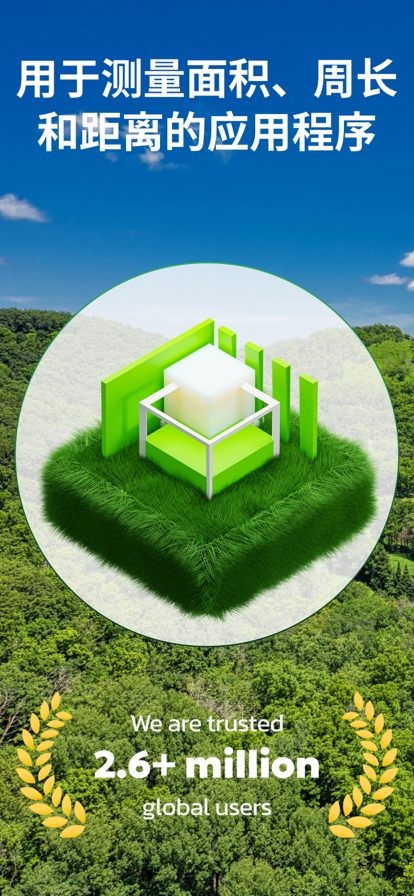
面积测量应用程序可帮助您测量任何大小的区域。 该应用程序有 4 个测量选项: - 地图上的测量允许您通过测量地图来获得场地或另一个大区域的粗略大小。 - 通过 GPS 跟踪进行测量可以帮助您通过在场地周围行驶或类似的东西来获得更准确的面积和距离值。 - 在 AR 中测量允许您通过在 AR 中放置对象并计算面积和周长来测量房间或桌子等区域或其他中小型区域 - AR 中的跟踪功能让您只需在其周围走动即可测量任何形式的面积。 所有这些案例涵盖了从小区域到大区域的任何区域测量需求。 您还可以保存测量结果并在历史页面中访问它们。 关于订阅 该应用程序包含每月订阅,价格为 4.99 美元/月。 每年订阅价格为 19.99 美元。 • 付款将在确认购买时从 iTunes 帐户中扣除 • 订阅会自动续订,除非在当前期间结束前至少 24 小时关闭自动续订 • 账户将在当期结束前24小时内收取续订费用,并确定续订费用 • 免费试用期的任何未使用部分(如果提供)将在用户购买该出版物的订阅时被没收(如适用) • 订阅可以由用户管理,并且可以在购买后转到用户的帐户设置来关闭自动续订 使用条款:https://sites.google.com/view/iriskinx/terms-of-use 隐私政策:https://sites.google.com/view/iriskinx/privacy-policy


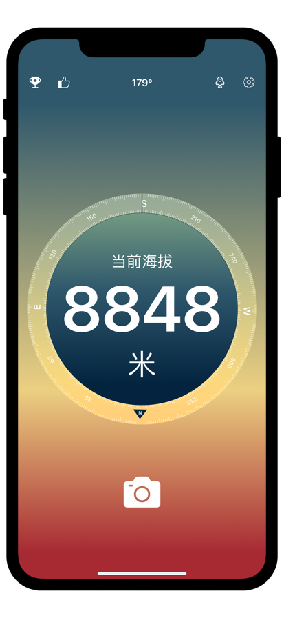
这是一款面向户外爱好者的GPS实时海拔测量应用,它提供强大的GPS实时海拔显示、当前坐标实时经度纬度显示、实时手机指南针功能,全球地震云播报,适合户外爱好者在国内外旅行、长短途徒步、登山、跑步、自驾越野、滑雪、户外摄影、野外寻宝露营以及其他户外活动时用作海拔记录与查看,还能把带着海拔信息的水印照片与好友及时分享。目前已集成各种卫星地图及标准地图。


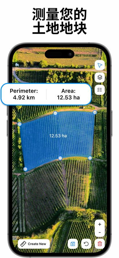
还在为土地测量费时费力、结果不准确而头疼吗?无论您是从事农业种植、工程测绘,还是土地投资交易,“GPS测亩仪”都能成为您随身携带的智能测量助手! 依托高精度GPS定位技术,我们为您提供快速、可靠的土地面积测量方案,让复杂测量变得简单直观,助您每一次决策都精准无误。 【高精度测量,快速出结果】 只需手持设备围绕地块行走,或在地图上轻松标记关键点,App即刻自动计算面积和周长。告别传统皮尺和复杂仪器,测量结果实时显示,并支持亩、平方米、公顷等多种单位切换,全面覆盖您的日常需求。 【智能测距功能,规划更高效】 快速测量两点或多点间的直线距离,适用于农田规划、道路建设或园区设计,让空间布局更科学,提升工作效率,节省宝贵时间。 【自定义绘图,应对复杂地形】 支持手动绘制任意多边形,无论地块形状规则还是不规则,App都能精准适配并计算面积。山地、坡地或零散土地?统统轻松搞定,解决各种复杂测量挑战。 【权威数据支持,保障权益无忧】 在土地流转、征地补偿或农业补贴申请中,App提供可靠的第三方测量数据,帮助您避免面积争议,维护自身利益。数据准确透明,让您在任何场景下都信心十足。 “GPS测亩仪”——已成为众多农民、工程师、地产经纪和投资者的首选工具,口碑见证专业品质。 精准测量是成功管理的第一步。立即免费下载,开启您的智能土地测量新体验! [自动续费会员] --订阅周期: 月/季/年 --付款方式:当用户确认购买并付款后记入iTunes账单 --续订: Apple iTunes账户会在当前订阅周期 24小时内扣除下一次的订阅费用,扣除成功后订阅自动延长一个周期 --取消续订:如需取消自动续订,应在当前订阅到期24小时之前前往Apple ID/iTunes 内关闭自动续订功能 隐私:https://jp.sdoc.ink/web/#/p/c7f02d9910b3abe8e73e5753c7ba19a3 用户:https://jp.sdoc.ink/web/#/p/3ca5948fa5f2cae97be71995b66eb321 付费:https://jp.sdoc.ink/web/#/p/49f6bee4d08c0329b61ebed934e3b89f


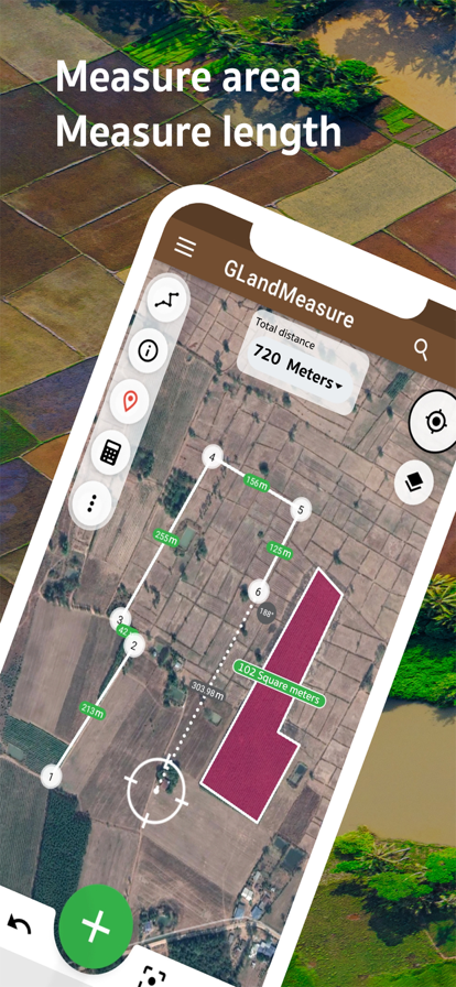
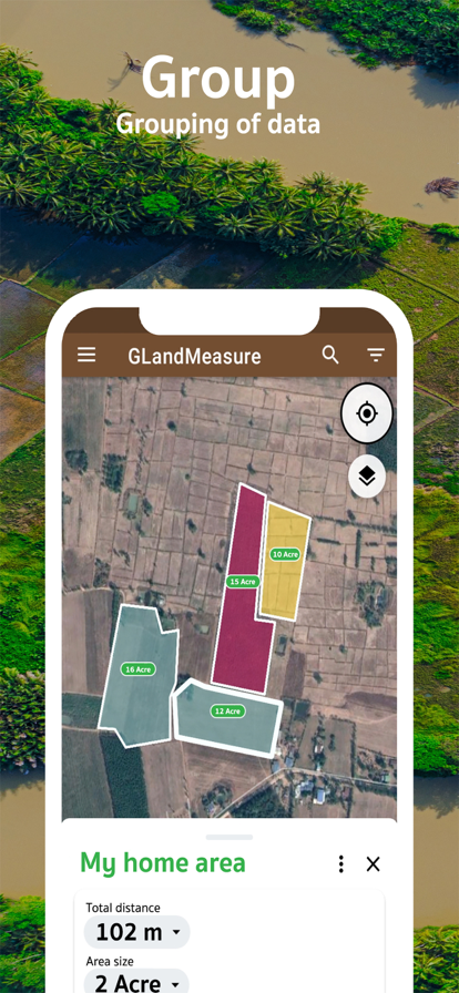
GLandMeasure是一款免费的应用程序,可用于测量面积和长度,可轻松测量土地,农场,田地,房屋,距离和长度。使用固定在地图上的方法或使用实际的步行方法该应用程序将计算面积和长度自动您还可以从几种类型的测量单位中进行选择。并且还可以轻松共享该区域的图像仅几步 免费下载的应用程序。 土地测量应用程序,测量距离或长度,查找农场坐标以及计算价格 有2种测量模式可供选择。实际上会走在庙里或选择在手机屏幕上按 1)长度或距离测量模式 2)土地面积测量模式(或在水泥面积上为55) 有许多测量单位可供选择。 1)长度测量模式 -泰制->英寸,蠕变,弯头,wa,线,yoch -英语系统->英寸,英尺,码,英里 -公制->毫米,厘米,米,公里 2)面积测量模式 -泰制->方华,工作,农场 -英文系统->平方英寸,平方英尺,平方码,英亩,平方英里。 -公制->平方米,公顷 测量数据可以保存在手机上。并且可以轻松地在Facebook或Line和其他人上共享

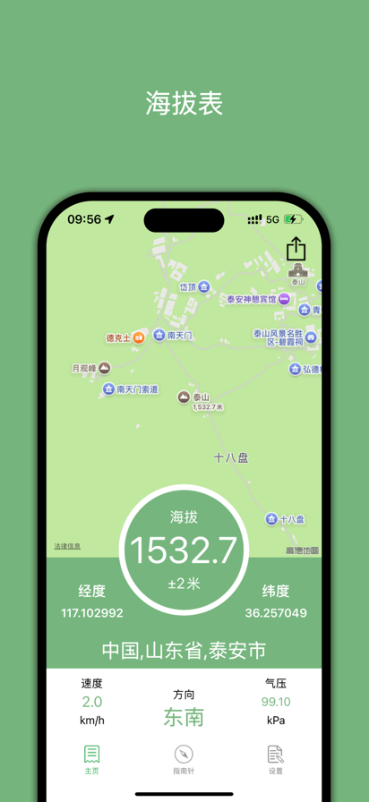
这是专业版,支持速度和气压显示,没有广告!数据更精准! 【产品简介】 这是一款喜欢户外的人士必备的一款APP,可以准确实时测量海拔高度,经纬度,方向等,还可以把带着海拔等信息的照片分享到社交网络! 【特色功能】 1、海拔表:准确实时显示当前海拔信息。 2、指南针:准确实时显示当前方向。 3、气压计:准确显示实时大气压力。 4、定位仪:显示当前经纬度和地址信息并在地图上显示。 5、速度计:准确实时显示当前实时速度。 6、社交分享:可以把相册里面或者相机拍摄的照片印上海拔等信息水印并分享出去。 【联系方式】 cnmaps@qq.com 【官方微博】 http://weibo.com/cnmaps 【官方网站】 http://www.cnmaps.net

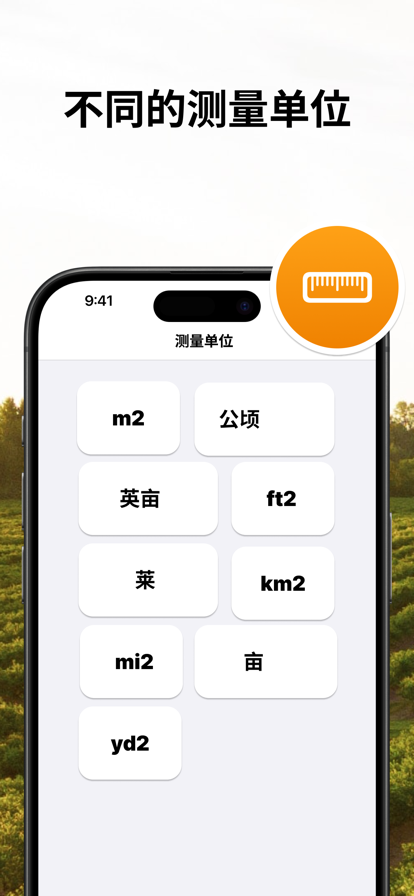
轻松高精度测量任何土地面积。准确的地图数据。 如果您从事土地测绘、规划农业工作,或者仅仅对您的住宅面积感到好奇,此应用程序将非常有用。 功能特点: - 通过在所测区域周围放置点标来手动测量土地面积。 - GPS测量:携带手机围绕您的地块边界行走来测量它。 - 提供多种测量单位:平方米、平方英尺、英亩、公顷、平方码、平方公里、公亩以及泰国的莱。 - 保存测量结果的能力。 - 使用iCloud进行云存储和跨设备同步。 - 导出测量结果为PDF文件的选项。 - 手动输入经纬度坐标。 - 通过电子邮件和即时通讯软件分享测量数据。 - 导入和导出GPX、KML、KMZ和GeoJSON文件的功能 使用条款:https://sites.google.com/view/webaspps998/terms-of-use


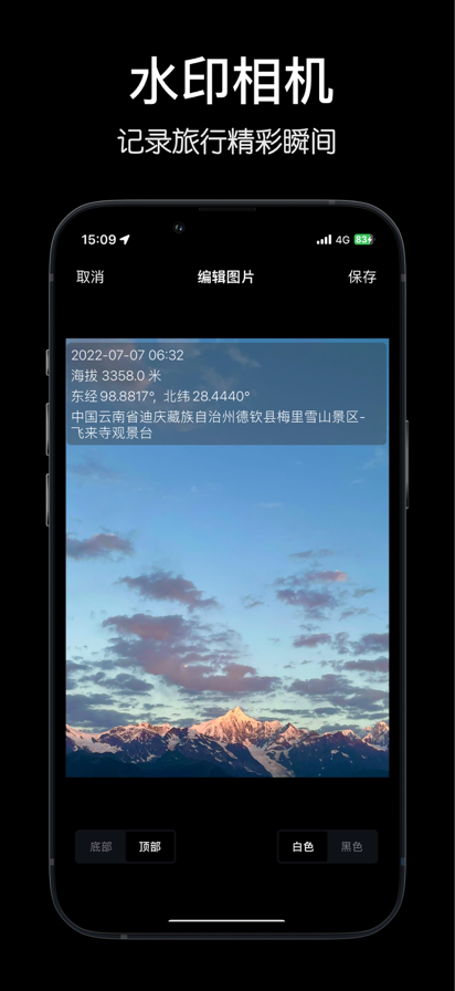
这是一款外出旅游、户外达人的必备的软件,让你以最快的速度准确实时测量海拔、大气压力、经纬度、GPS位置、方向、速度和气压等信息,还可以把带着海拔等信息的照片分享到社交网络! 【特色功能】 1.海拔表:实时测量海拔,无需网络就可以准确测量所在地的海拔和经纬度,支持单位在米和英尺间切换。 2.指南针:本软件内置指南针,让你更快的获取所在地的方向。 3.定位仪:显示当前经纬度和地址信息并在地图上显示。 4.气压计:精准显示大气压力值。 5.水印相机:不错过在高山之巅的最美一刻?来一张水印自拍吧,照片上会以水印记录拍照时所处的海拔。 【适用场景】 - 登山、徒步旅行 - 自驾游及露营 - 地理探险和科研活动 - 日常运动和健身 我们专注让每一次探险都更安全、更有趣!无论您身在何处,随时掌握海拔信息,开启您的精彩旅程。立即下载,体验高效便捷的海拔测量! 使用条款:https://www.apple.com/legal/internet-services/itunes/dev/stdeula/


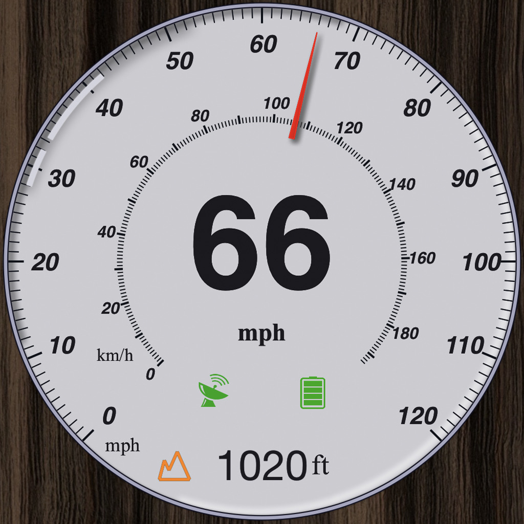
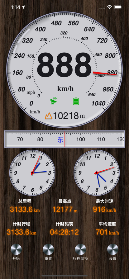
简洁美观的测速仪,超大字体让你一眼看清当前的 GPS 速度,支持 km/h 与 mph 切换。 • 实时 GPS 速度,超大数字清晰易读 • 一键切换 km/h 与 mph • 浅色、深色、自动三种主题 • 内置信号质量指示器,随时掌握 GPS 状态 • 支持竖屏与横屏,iPhone 与 iPad 均可使用 • 界面简洁,毫不干扰 Speedometer ∞ Pro 解锁: • HUD 平视显示模式 — 将速度镜像投射到挡风玻璃 • 去除广告 • 所有未来的 Pro 功能 免费版可以一直继续使用。 适合开车、骑行、跑步、乘船,以及任何需要比设备默认显示更大、更清晰速度读数的场景。 Privacy Policy: https://apps.fawkeswei.com/speedometer/privacy/ Terms of Use: https://www.apple.com/legal/internet-services/itunes/dev/stdeula/


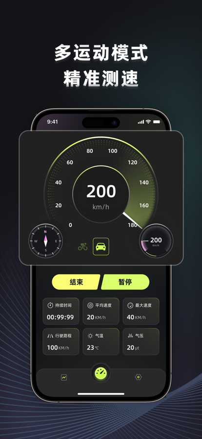
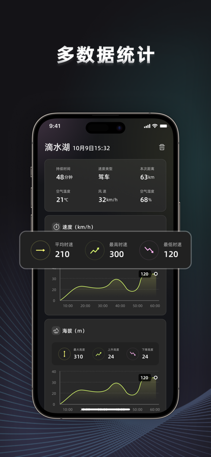
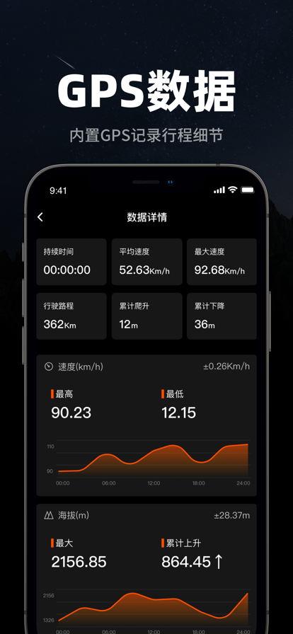
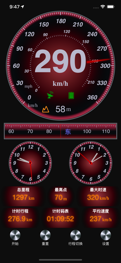
GPS测速仪是跑步、骑行、驾驶或任何涉及速度的户外运动的完美伴侣。 简单列举下功能: ==多运动模式精准测速== ▸ 仪表盘布局显示当前速度、总里程、海拔、指南针 ▸ 列表展示行程时间、里程、平均速度、气温等信息 ==多数据统计== ▸ 详情页可以详细查看当次行程细节 ==单次测速详情对比== ▸ 历史纪录详细记录每次行程历史 ▸ 运动轨迹地图标注,速度时间图表展示 重要使用注意事项: ▸ 我们的速度跟踪器基于GPS信息。与设备硬件传感器的限制,GPS 传感器并不总是准确的。如有疑问,请始终依赖汽车的车速表。 ▸ 当您处于开阔的空间时,GPS 最为准确。树木、高层建筑和其他物体可能会影响您的 GPS 准确性。 ▸ 注意安全,驾驶时专注于前方道路,不要与任何设备互动。

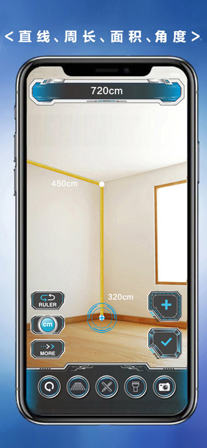
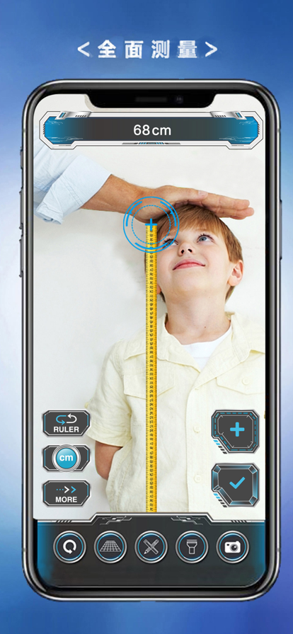
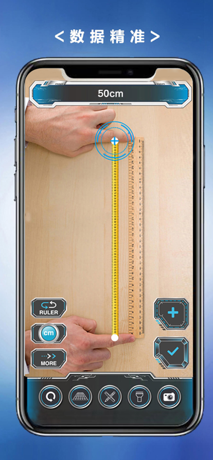
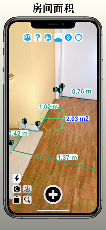
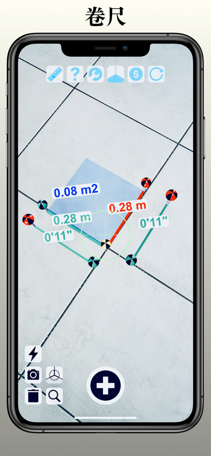
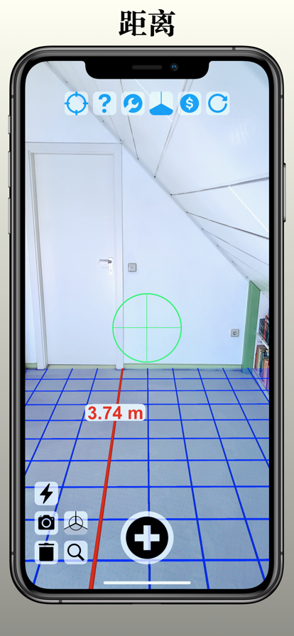
Fancy AR尺子是一个增强现实(AR)测量应用,基于最新的AR技术将你的iPhone手机或iPad平板镜头瞬间变成一把精准的量尺。它可以进行水平测量和垂直测量,测量物体的长度、角度、高度和面积。还可以通过相机拍照将测量结果保存在相册里。 特性包括: * 长度和距离的单段和多段测量 * 身高测量 * 不同测量模式的灵活切换 * 多次测量,支持同时测量长度,角度,面积,周长,高度等 * 一键截图保存测量结果 * 清晰的测量线和测量结果文字 * 仿真量尺 * 闪光灯 * 辅助平面坐标系 * 测量单位转换(厘米,米,英寸,英尺) 使用提示:启动AR尺子应用后,请先左右移动你的手机设备,扫描检测到稳定的平面后,再开始进行测量。建议开启辅助平面坐标系网格,在显示的辅助平面内进行测量时,结果最为精确。 Fancy AR尺子是你随身必备的口袋测量工具,可以随时随地用手机测量长度、测量距离、测量身高、测量角度、测量高度和测量面积等,功能强大,立即下载开始体验吧!
用iPhone进行GPS土地测量 -- 使用公顷.应用可轻松用iPhone测量你的土地。只需围绕土地步行即可完成。 导出测量 -- 通过邮件将测量作为GPX文件发送 支持多种单位 -- 公顷.应用不仅支持公顷,还支持按英亩和平方千米测量


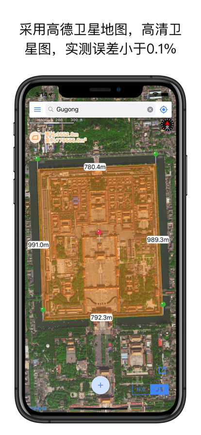
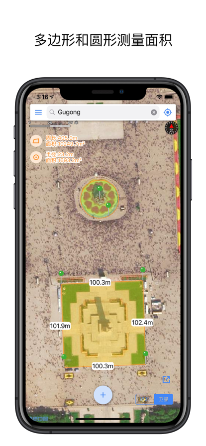
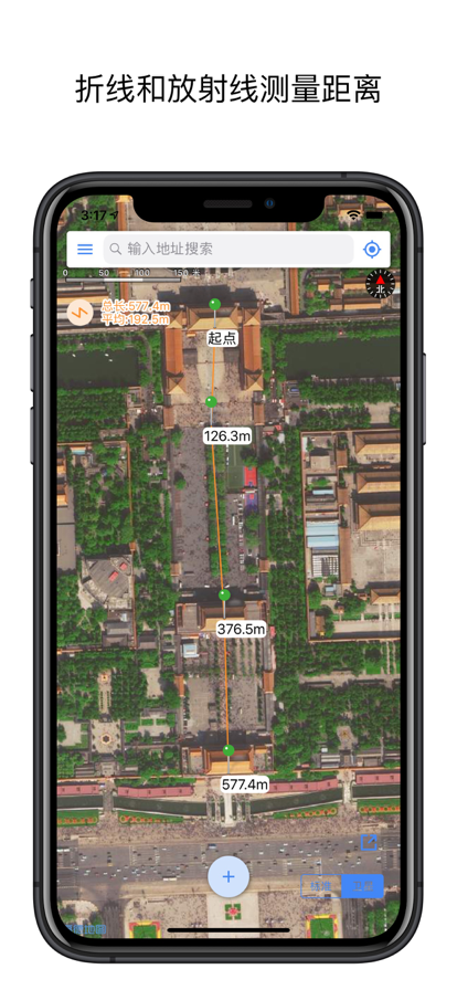
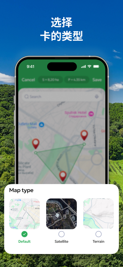
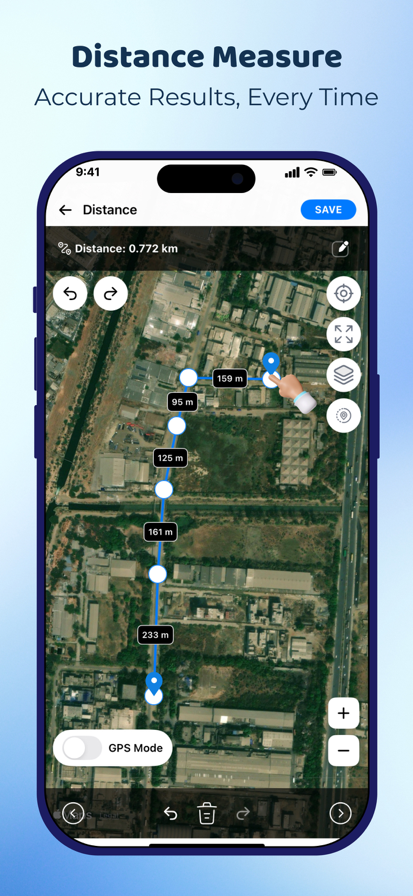
网页版的地图都带有测距功能,到了手机App上就没有了。没关系,距离与面积为您带来更好的测距工具。 专业测距工具,不仅能测量多种形式的距离,还能测量区域面积,不仅好还全。 功能特点: 1、采用国内分辨率最高,最清晰的高德地图作为地图源。 2、支持多种测量图形,折线、多边形、圆形和放射形。 3、支持同时测量多个图形。 4、支持测量距离,周长,面积,半径等多种数据。 5、操作简单,精确。 6、同时支持iPhone和iPad。 7、支持地图通过KML文件导入与导出。 8、内建测量文件管理,可无限保存测量结果。 入门操作: 1、 点击下方 + 按钮开始测量。 2、移动地图,将中央十字光标对准测量位置。 3、点击地图任意位置添加一个测量点。 4、依次添加测量点即可完成测量。
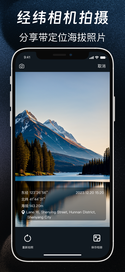
GPS定位助手是一款能实时测定海拔高度、经纬度坐标、大气压值、含氧量及位置信息的实用工具箱。 基于GPS定位数据提供服务,数据准确性高,定位误差极低。实时测算各项数据,为你户外旅行保驾护航。 可记录外出旅行、徒步跑步、登山滑雪、自驾越野、户外摄影、冒险露营等信息数据,生成并分享定位水印照片。


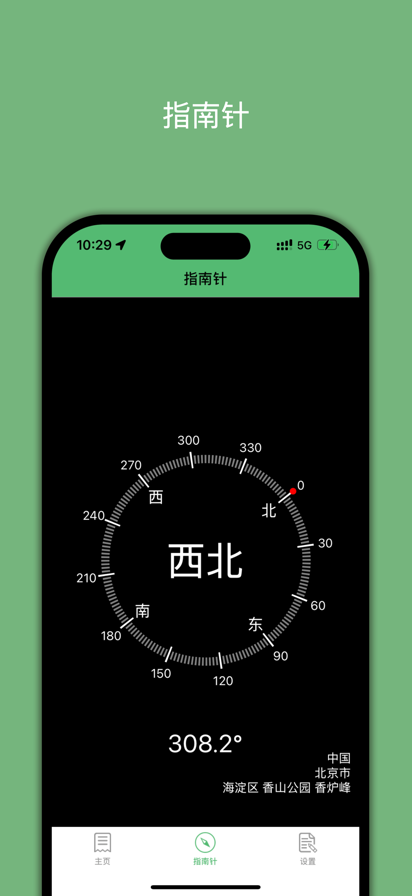
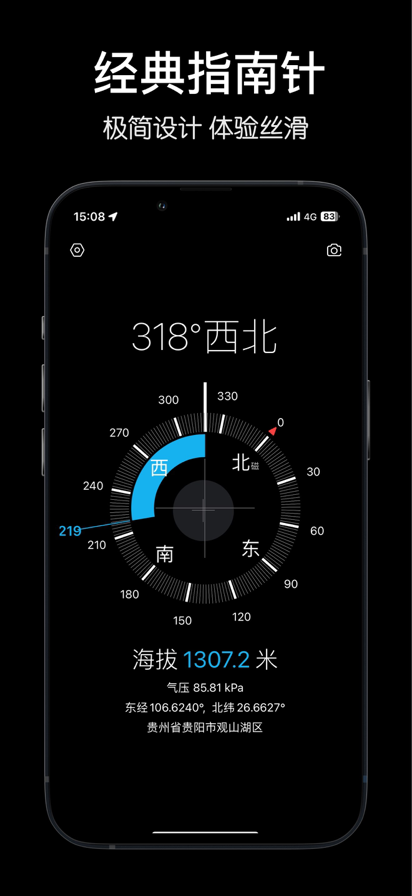
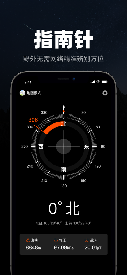
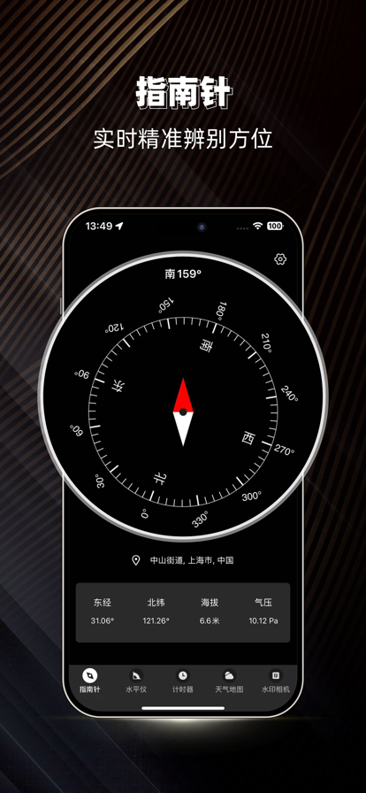
这是一款设计简约、风格时尚的指南针应用,精准显示当前方向、实时海拔、经纬度坐标、实时气压、移动速度和地理位置等实用信息。特别提供「经典」与「落日」两款精心设计的视觉主题,均采用高级配色方案,带来沉浸式的使用体验,是户外探险与城市导航的完美伴侣。

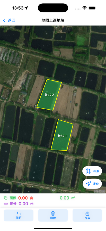
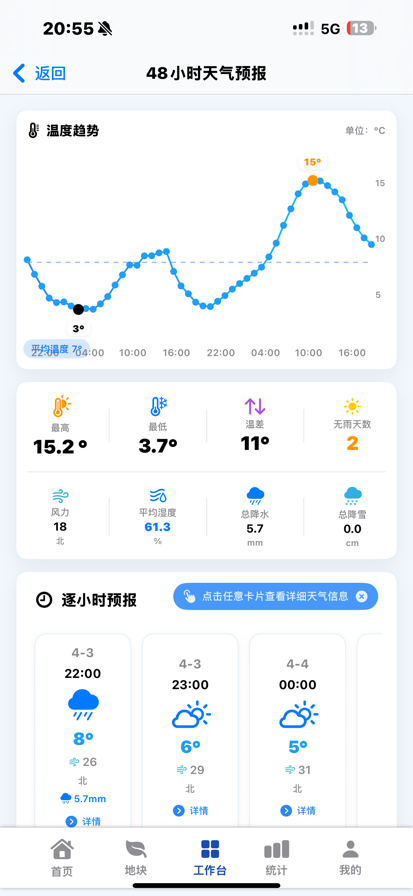
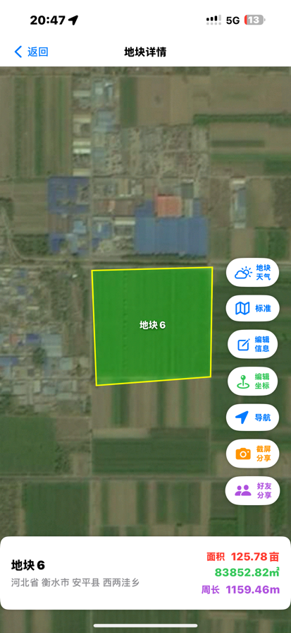
慧亩宝是一款专业农业数字化管理平台,支持 GPS 测亩、农田面积测量、农事记录、收支统计、作物产量管理与地块天气预测,让农业生产更高效、更智能。 适用于:• 农户 • 家庭农场 • 合作社 • 农业公司 • 土地承包经营者 支持: • GPS精准测亩 • 农田地块管理 • 农事记录 • 农资与费用统计 • 作物产量生成 • 农业收支管理 • 未来48小时与7天天气预测 • 地块分享与农业社交 【订阅方案】 月度订阅:8元/月 年度订阅:88元/年(更优惠,省8元) *支持自动续费 【订阅权益】 多功能测亩:支持实地绕行测量与地图画地测量,适应多种使用场景 地块管理:地块信息一键保存、分组查看、快速导航,方便随时调用 【自动续费说明】 购买即视为同意从您的Apple ID账户扣款; 订阅周期结束前24小时内,将自动从账户扣费并延续一个周期; 如需取消续订,请至少提前24小时操作: 打开 iPhone【设置】→【iTunes Store 与 App Store】→ 点击【Apple ID】→【查看Apple ID】→【订阅】→ 选择“慧亩宝”取消订阅。 若未提前取消,将视为同意继续订阅,并自动扣费续期。 【用户使用协议】 https://jinghuijiangxin.com/LoginAgreementApp 【用户隐私协议】 https://jinghuijiangxin.com/LoginSecurityApp 【自动订阅服务协议】 https://jinghuijiangxin.com/LoginSubscriptionApp 【技术支持】:19114618105
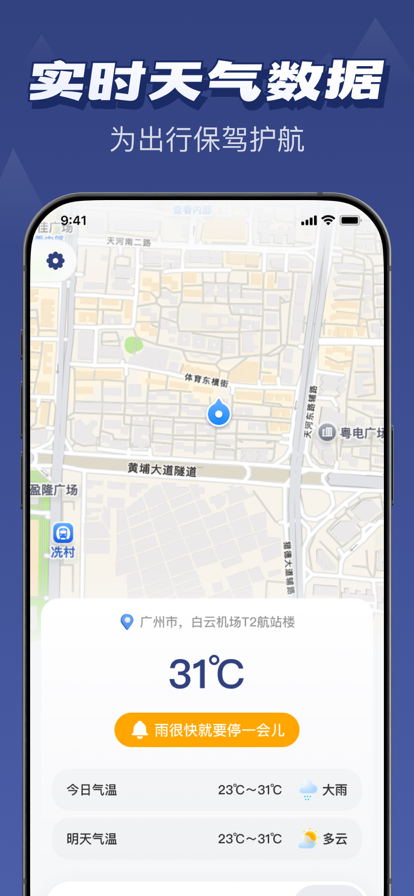
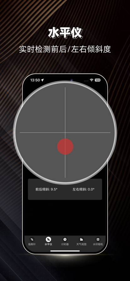
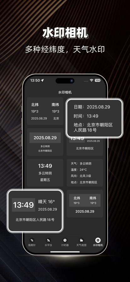
指南针:精准定位,全能探索,你的户外出行必备神器! 无论你是户外探险爱好者,还是日常生活中的实用工具需求者,指南针App都能为你提供全方位的定位与导航服务。集五大核心功能于一体,让你随时随地掌握方位、海拔、轨迹、天气信息! **【核心功能】** ** 精准指南针** - 实时显示东南西北方位 - 结合手机传感器,精准定位方向 - 户外徒步、越野探险不再迷路 - 界面简洁直观,一秒上手 **专业水平仪** - 悬挂画框、安装家具必备 - 调试设备、测量角度精准可靠 - 生活中处处保持平衡 **运动轨迹记录** - 实时记录你的运动路线 - 统计运动距离、时长、速度 - 回放历史轨迹,复盘每一次出行 - 户外徒步、骑行、跑步全覆盖 ** 实时天气预报** - 基于GPS位置精准推送天气 - 24小时天气变化监测 - 出行前提前规划,从容应对 **水印相机** - 拍照自动添加经纬度、海拔、天气信息 - 记录每一刻的地理位置 - 分享照片自带打卡水印 **【适用场景】** 户外徒步、登山探险 旅行导航、自驾出行 日常家居测量(水平仪) 运动健身记录 摄影打卡分享 指南针App用科技的力量,将方向、海拔、轨迹、天气、水印融为一体,开启"精准定位,自在探索"的智能新体验! 隐私政策:https://www.zhuoxiangkj.com/privacy_policy/Compass/policy_cn.html 用户协议:https://www.zhuoxiangkj.com/privacy_policy/aiResume/protocol_cn.html
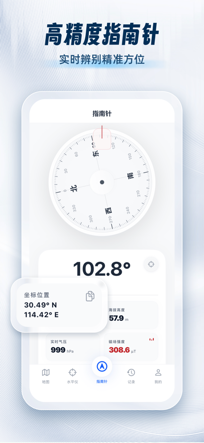


一款专业的指南针工具,帮您辨别方向及查看经纬度、海拔,显示经纬度、海拔、气压、风向、GPS测速、环境变化等实时数据,支持经纬相机、地图模式、GPS测速等工具使用,满足专业人士的户外需求 订阅版功能 1. 直观查阅经纬度、海拔,气压、暴风雨预警、日出日落等实时数据无限次 2. 掌控累计爬升、累计下降、平均配速等关键数据无限次 3. 经纬相机不限次 4. 暴风雨预警 * 订阅依照选择的订阅计划的价格,包括每年自动续订98元(享试用3天) * 该定价和“Apple's App Store Matrix”在其他货币所确定的价格区间相同。 * 如果您没有在免费试用到期前至少 24 小时关闭自动续费,您的免费试用将会自动更新为付费使用。 * 请注意:您如果在免费试用期(如有提供)内购买高级订阅,免费试用期任何未使用的部分均将被视作放弃。 * 您随时可以通过 iTunes 账户设置关闭自动更新以取消免费试用或订阅。此操作必须在免费试用期或订阅期结束前 24 小时完成,以免产生费用。取消将在当前订阅期最后一天之后的日期生效,您将被降级到免费服务。 * 帐户将在当前期间结束前24小时内收取续订费用,并确定续订费用 【温馨提示】指南针配速会持续使用GPS定位服务,切换到后台仍会继续,相比其他操作会消耗更多的电量,并影响到电池续航时间。 隐私政策: http://privacy.xinzhi.space/compass/compassPrivacy.html 使用条款: http://privacy.xinzhi.space/compass/UserAgreement.html -------------------------------------------------- ------------------ 遇到任何问题,请通过以下方式联系我们,让我们解决! 官方邮箱:844526412@qq.com
获取您需要的地球任何部分的数据!找出您感兴趣的物体或空地的周长/面积/距离。 • 获取任何一块土地的准确数据 • 该应用程序支持任何大小的地块和任何位置 • 距离跟踪器 • 最准确的测量结果 • 在库中保存对象 该应用程序有免费试用期以及各种订阅选项,通过这些选项,您将获得无限数量的测量、访问库、无广告和其他有用的好处。 其他订阅信息: - 确认购买后,费用将从您的 Apple ID 帐户中扣除。 - 除非在当前期限结束前至少 24 小时关闭自动续订,否则订阅将自动续订。 - 购买后,您可以转到 App Store 帐户设置管理订阅并禁用自动续订。 - 您将在当前期限结束前 24 小时内收到续订费用。 - 您可以随时在 Apple ID 设置中取消订阅。所有价格均含适用的当地销售税。 - 如果提供免费试用,则未使用的部分将在购买订阅时取消。 - 优惠仅限于每周订阅的一次 3 天试用。在 3 天试用期结束时,除非在 3 天试用期结束前取消,否则订阅将根据资费自动续订。 用户隐私和数据安全是我们的首要任务。有关更多信息,请访问我们的隐私政策。 https://fsiciscrl.com/policy.html https://fsiciscrl.com/terms.html

GPS测速仪 - 跟踪您的速度和行程! 您是冒险爱好者或热衷于追踪速度和行程的人吗?不用再寻找了!GPS测速仪是您追踪速度和行程的完美伴侣。利用强大的定位算法,GPS测速仪提供了丰富多样的数据,包括纬度、经度、速度、海拔、航向、日出、日落、加速度、距离等,为您带来终极的导航和跟踪体验。 • 主要功能: 1. 实时速度显示:无论您偏好英里每小时(MPH)、每小时公里数(KM/H)还是节(KNOTS),GPS测速仪都能满足您的需求!轻松切换不同速度单位,以适应您的个人喜好和方便使用。 2. 数字速度表与HUD:通过数字速度表显示,随时了解您的当前速度。如果您喜欢更便捷的显示方式,抬头显示(HUD)模式可将速度直接投射到挡风玻璃上,确保您在查看重要信息时保持对路面的注意。 3. 跟踪行程距离:通过跟踪您的行程,轻松掌握您的旅程距离。无论您是在乡村骑行还是在高速公路驾驶,GPS测速仪都会准确记录您的行程距离。 4. 指南针显示:通过内置指南针,始终找到您的真北。无论您是在探索新城市还是徒步穿越荒野,指南针都会指引您走向正确的方向。 5. 高度计,海拔跟踪:通过监测您当前的海拔高度,提升您的冒险体验。无论您是攀登高山还是乘坐飞机高飞,GPS测速仪都会记录您的海拔高度,为您提供有关垂直移动的宝贵数据。 6. 日出日落:出门骑行在外,随时关注天气情况,帮助您更好规划行程。 7. 灵活的单位设置:我们理解个人偏好各异,因此GPS测速仪让您轻松自定义单位设置。只需点击几下,即可在公里每小时、英里每小时或节之间切换。 • 重要提示: 请注意:持续在后台运行GPS可能会消耗设备电量。 立即下载GPS测速仪,体验跟踪速度和行程的乐趣!无论您是公路旅行爱好者、经验丰富的徒步者还是热爱航海的狂热爱好者,GPS测速仪都是您的终极应用!如果您有任何反馈或问题,请随时通过miaozhi.ai@gmail.com与我们联系。


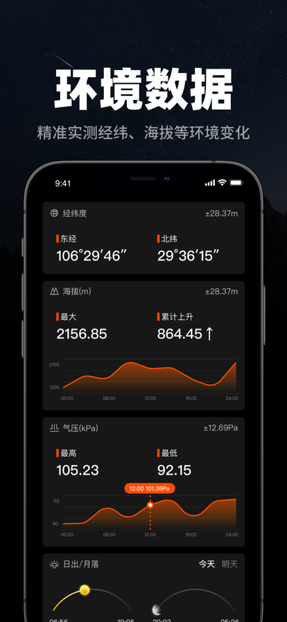
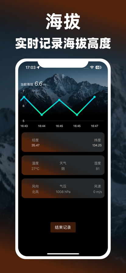
指南针-海拔测量仪实时高度GPS经纬度定位是一款专为户外探险、旅行和日常导航设计的全能工具类应用,集指南针定位、海拔测量、轨迹记录、天气查询于一体,助您轻松应对复杂环境,探索未知更安心。 核心功能亮点: - 精准指南针 实时显示方位角度,支持360°旋转指针与数字方向(东/南/西/北)。自动校准传感器,适应不同地理环境,确保定位精准可靠。 - 海拔测量仪 基于GPS与气压计双重数据,实时测量当前位置海拔高度。 - 自动记录您的移动轨迹 生成可视化路径地图,随时回看行程路线,满足徒步、骑行等运动需求。 - 实时天气与环境查询 提供当前位置的精准天气预报,包括温度、湿度、风速、降水概率等,规划行程更科学。 应用场景: 户外探险:登山、徒步、露营时精准导航,规避迷路风险。 旅行记录:自动生成旅途轨迹,留存独特地理印记。 常生活:快速查询天气,应对突发气候;校准方向,提升方向感。 开通订阅后,您的 iTunes 账户将被自动扣费,以确保您在每个订阅周期内可继续享受相关高级功能。系统将在每个订阅周期结束前一天自动从您的 iTunes 账户中扣除订阅费用。 所有订阅费用仅通过 Apple 的应用内支付渠道(即 iTunes 账户)进行支付,本应用目前仅支持 Apple 的官方支付方式,其他第三方支付方式暂不支持。为确保顺利完成支付,请确保您的 iTunes 账户具有足够的余额。 若由于账户余额不足或其他原因导致支付失败,您将暂时无法使用订阅相关的高级功能,直到费用支付成功。 在您开通订阅后,系统将自动从您的 iTunes 账户扣除续订费用。如果您不希望继续订阅,您可以随时按照以下步骤取消自动续费功能:打开 iOS 设备上的“设置”应用 > 点击您的 Apple ID 头像,选择“iTunes 与 App Store” > 点击您的 Apple ID 并选择“查看 Apple ID” > 在“账户设置”页面中,找到并点击“订阅”选项 > 在订阅列表中找到“指南针 - 海拔测量仪实时高度 GPS 经纬度定位”应用并点击“取消订阅”。 用户协议:https://note.youdao.com/s/Ohd0XC0q 隐私政策:https://note.youdao.com/s/a72uwM6B 温馨提示:为确保准确获取海拔、环境信息和记录轨迹,部分功能可能会在使用中和切换至后台时持续使用卫星定位服务,这可能导致更多的电量消耗并影响电池续航时间。


专业指南针App,精准定位你的世界,探索未知的无限可能! 我们为你打造一款全能户外导航与生活助手,五大核心功能助你轻松应对各种场景: 【精准指南针】:内置高精度电子指南针,实时指示方向,无论山林野径或是城市巷陌,永不迷失,一路向前! 【海拔与经纬度定位】:实时查看当前位置的海拔高度、经纬度坐标,精准掌握地理信息,户外探险、旅行记录更专业。 【智能水平仪】:内置水平测量工具,轻松检测物体平面水平状态,家居布置、设备安装,一举一动皆平衡。 【实时天气】:提供当前位置的实时天气信息,包括温度、湿度、风力等,出行规划随时掌握天时地利。 【水印相机】:拍照自动添加时间、地点、海拔经纬度水印,记录旅途精彩瞬间,让每一张照片都充满地理印记。 无论你是户外探险爱好者,还是注重生活效率的日常用户,指南针App都能以科技为你指引方向、记录轨迹,开启“精准生活,随心探索”的智能体验! [自动订阅付费说明] 1. 订阅服务:订阅VIP会员,解锁全部高级功能与高清输出权限 2. 付款:用户确认购买并付款后,费用将计入iTunes账户; 3. 订阅自动续费:订阅服务将在到期前24小时内自动扣费,扣费成功后订阅周期顺延一个周期; 4. 关闭订阅服务:前往苹果手机“设置”→“iTunes Store与App Store”→点击“Apple ID”→选择“查看Apple ID”→进入“账户设置”→点击“订阅”,管理或关闭自动续费(需在计费周期结束前24小时操作,避免扣费); 隐私政策:https://docs.qq.com/doc/DY1VRd2ZFaGx4eFFo 用户协议:https://docs.qq.com/doc/DY2h4Z3FueEtTQ0RM 会员服务协议:https://docs.qq.com/doc/DY1NjSXFvbXZHZk9m 自动续费服务协议:https://docs.qq.com/doc/DY3doVGpqSFRHTHNO


1.强大的设计功能与地理信息展现技术,可满足各行各业地理信息规划的需求 2.强大的地图标注和点线面计算功能,海拔查询,轨迹记录等丰富实用小工具 3.行政区域,钓点分布等众多人文和自然数据可视化展示 4.可以和好友分享自己的位置与轨迹,也可以根据分享的位置进行卫星定位,指导好友走出迷途 5.内置导航功能 会员服务以及自动订阅说明 1.订阅服务:新知地图会员月卡订阅(1个月),新知地图会员年卡订阅(12个月) 2.订阅价格:月卡订阅产品为40元/月,年卡订阅产品为128/年 3.购买价格:终身会员产品为198元 4.付款:用户确认购买并付款后计入iTunes账户 5.苹果iTunes账户会在到期前24小时内扣费,扣费成功后订阅周期顺延一个订阅周期 6.如果取消订阅,请打开苹果手机“设置” —进入“iTunes Store 与 App Store” —点击“ App ID” 选择“查看Apple ID” ,进入“账户设置”页面,点击“订阅”,选择新知卫星地图取消订阅,如未在订阅期结束的至少24小时前关闭订阅,此订阅将会自动续订 用户协议(包含连续订阅服务规) :https://xinzhi.space/serviceAgreementIOS.html 隐私政策:http://xinzhi.space/privacyPpolicy.html -------------------------------------------------- ------------------ 遇到任何问题,请通过以下方式联系我们,让我们解决! 官方邮箱:765559466@qq.com


GPS位置记录与共享应用主要功能: 1. 手动记录GPS地理位置经纬度坐标。 2. 自动连续记录GPS地理位置经纬度坐标。 3. 实时显示UTM坐标。 4. 编辑记录位置的名称与描述。 5. 列表浏览记录的所有位置信息。 6. 在地图上标注记录的所有位置信息。 7. 通过邮件导出记录的所有位置信息或者部分记录信息。 8. 支持TXT,CSV,JSON,GPX,KML,XLS与UTM七种记录数据文件格式。 9. 通过短信或者邮件将用户当前所在位置的GPS经纬度信息告诉他人。 10. 将自己的当前所在位置上传到微博,facebook,twitter等。 11. 提供GPS时速表,里程表与海拔表。 12.中国区的用户,可以将当前所在位置分享到微信朋友圈。 该应用使用场景: 1. 自动连续记录行车路线与跑步健身路线。 2. 做远程监控系统的企业用户,可以使用该应用采集待监控设备的地理位置。 3. 喜欢旅游探险的个人用户,可以使用该应用记录走过的重要地点。或者将旅游地点随时分享给他人。 4. 朋友聚会,婚礼等重要时刻,将地点发给不熟悉地点的朋友。 5. 出差在外的员工,可以将位置分享给公司。 6. 出门在外的孩子,可以将位置分享给父母。 7. 迷路时,可以将位置发给朋友,以便朋友定位提供帮助。 8. 灾难救援时,可以将自己的位置分享给救援人员。 9. 到一个新环境下,可以记录住地,重要地点,以避免迷路。 10. 外出自驾旅游时,记录停车位置,方便旅游结束后找车。 11. 散步或者跑步时,不仅可以知道运动速度,而且可以知道距离。 12.家人或者朋友可以通过微博,facebook,twitter等看到你的位置。 13.爬山时,可以随时知道高度。 14.随时可以将GPS位置分享到微信朋友圈,这样很方便他人找到自己。 15.公司招聘面试时,HR可以将公司具体位置发给应聘者。 16.使用Google earth规划:将记录的位置信息导出成KML或者GPX格式,可以在Google earth上直观看到。 【溫馨提示】: 自动记录GPS位置与路径会持续使用GPS定位服务,切换到后台时,仍会保持GPS连接,相比其他操作会消耗更多的电量。 GPS在后台持续运行会影响电池续航时间。 该应用我们将持续不断更新,提供更好更方便实用的功能。非常感谢您的支持。 反馈邮件:zhang_jian_wu@msn.com QQ技术支持: 1051094736


神行天下,方向为先,一款优秀的海拔数据产品能带您上山下海。 功能亮点: 海拔:精确的海拔数据,实时更新的海拔高度表 GPS加持:GPS加持下的海拔数据更准确,数据更新更及时 风速:实施展示当前风速 精准指南针:无论是户外探险还是城市漫步,我们的高精度指南针功能都能确保您永远找到正确的方向。界面简洁,操作方便,是您值得信赖的导航伴侣。 经纬度:高精尖卫星定位经纬度,实时掌握准确的位置信息。 24小时天气预报:实时更新您当前位置的天气状况,包括温度、湿度、风速等信息,让您随时做好出行准备。 未来6日天气预测:规划前置,不仅知晓今天,更能预见未来6天的天气变化,为您的日程安排提供有力参考。 全球时差查询:一键查看莫斯科、纽约、东京这些国际大都会的当前时间,无论跨国会议还是远方亲友连线,都能轻松掌好时机。 当日详细天气:除了基本天气信息,还提供日出日落时间、空气质量指数、穿衣建议等贴心提示,让每一天的生活更加精致。 内置地图:集成高精度地图服务,支持多种地图模式切换,无论是寻找路线还是探索未知区域,都能得心应手。 适用场景: 户外活动:登山、徒步、野营时的好伴侣,帮助您在大自然中保持方向感。 旅行出行:出国旅游或商务差旅,即时查询目的地天气,合理安排行程。 日常生活:上下班、接送孩子、购物逛街,根据天气变化选择合适穿着,享受更舒适的生活。 学习工作:了解不同城市的时差,优化国际沟通与协作时间。 使用方式: 下载并打开应用,即可直接使用指南针功能。 开启定位权限,以获取准确的天气预报和地理位置信息。 在设置中,您可以自定义添加或删除需要关注的城市时间,以及选择地图类型和天气提醒偏好。 用户好评如潮: “这不仅仅是一个指南针,它是我出行必备的万能工具!”—— 探险爱好者@山野行者 “有了它,我再也没错过过任何一场重要国际会议的黄金时间。”—— 商务人士@飞行者 “每日穿搭建议超实用,再也不用担心天气变化了!”—— 时尚博主@潮流先锋 结语: 在这个快节奏的时代,让“指南针”成为您口袋里的智能助手,无论是探索世界的每一个角落,还是享受日常生活的每一刻,它都将是您可靠的伙伴。立即下载,开启您的智慧生活之旅! 协议内容 用户协议:https://docs.qq.com/doc/p/ce625b9fa90ac0e0b97d9a0c3a32db4f949a5794 隐私协议:https://docs.qq.com/doc/p/e6a17f377867431cd7f821b5c3f61f34a6672546 我们的应用中包含了一个或多个订阅服务,包括包含免费试用的商品,商品订阅相关费用会由苹果公司通过用户授权的iTunes账户自动扣款,每个续订前24小时内可前往授权iTunes账户内关闭自动续订


GPS Fields Area - Measure Map – 测量距离、面积和英亩数的终极工具! 正在寻找一种简单准确的方法来测量距离、绘制区域地图、计算英亩数并标记特定位置?GPS Fields Area - Measure Map 就是您的理想之选!只需轻点几下,即可快速测量距离、计算田地面积(以英亩为单位)并在地图上标记重要地点! 主要功能: 精确距离测量 测量地图上任意两点之间的距离。无论您是计划徒步旅行、标记房产边界还是计算旅行距离,GPS Field 都能实时提供准确的结果。 田地面积测量和英亩计算器 轻松计算任何田地、房产或地块的面积。只需放置标记来勾勒边界,我们的应用程序即可立即计算总面积,包括英亩数!非常适合农民、土地所有者、测量员以及任何需要处理大型户外空间的人士。 自定义标记和位置 放置自定义标记并在地图上保存您喜欢的位置。无论您是绘制土地地图还是跟踪重要地点,GPS Field 都能让您轻松组织和随时访问您的测量数据。 简单直观的界面 无需任何技术技能!我们易于使用的界面意味着您可以在几秒钟内开始测量。只需在地图上放置标记,剩下的就交给 GPS Field。只需极少的努力即可获得准确的距离和面积计算结果。 完美适用于: • 需要准确计算英亩数的农民和土地所有者 • 测量大面积地块的测量员和地理学家 • 绘制房产边界的建筑商和建筑师 • 跟踪徒步旅行距离和路线区域的户外运动爱好者 • 计算房产土地面积的房地产专业人士 为什么选择 GPS Field? • 准确可靠:采用高精度 GPS 技术,确保精准测量 • 英亩计算器:立即将面积测量结果转换为英亩,方便进行土地评估 • 简单快捷:只需几秒钟即可测量任何区域或距离,设置简单 • 可自定义标记:保存位置、标签和边界,以便日后参考 使用条款 - https://pdbtechsol.blogspot.com/2025/12/term-of-use.html 隐私政策 - https://pdbtechsol.blogspot.com/2025/12/privacy-policy_22.html


本应用是一款专业指南针定位工具,显示经纬度海拔天气等数据,支持GPS测速功能! 方便您便捷的了解所处地理位置情况,保护您的人身安全! * 我们的标准订阅选项为: 提供专业版订阅,包含连续包年的订阅,订阅会自动更新,期间可告别广告打扰; 不限制使用所有功能,解锁所有专业版内容; * 在您确认购买时和每个续费周期开始时,我们会从您的 iTunes 账户中收取订阅费用。 包含免费试用期的订阅将自动续订为付费订阅。 在免费试用期结束前至少 24 小时,您可以在 iTunes 设置中取消您的订阅或免费试用。 取消订阅将会在当前订阅周期最后一天后生效,一旦取消订阅生效,您的订阅服务权限将失效。 隐私政策:http://bnznz.other1.site/bnys.html 用户协议:http://bnznz.other1.site/bnfw.html


无广告,清爽不打扰! App 支持显示当前位置的海拔、气压、经纬度等环境信息: 1. 支持切换 GPS 信息或手机高度计作为海拔数据信源。 2. 支持深色及浅色模式、 UI 自定义功能。 5. 支持切换海拔、气压及位置数据的显示模式。 6. 无任何烦人的广告、无乱扣费的订阅、无任何隐私收集。 7. 超小的体积、超快的速度、超少资源占用、下载安装使用无负担 我们的设计理念就是摆脱庸俗、繁琐的元素,应简尽简。 如果您有任何疑问或者建议请联系我们: 邮箱:laoshiduo@163.com 我们期待您的意见!


使用我们完整重写的“增强现实卷尺相机”应用程序,或是测量尺寸如高度、长度、宽度、大小、矩形范围和与相机的距离,轻松测量房间的地板范围。我们现在正在使用ARKit增强现实技术。您在观看相机预览时,“增强现实卷尺相机”会在相机视图中,使用虚拟3D测量显示宽度、长度、距离和高度。 没有卷尺或量尺,您也可以轻松地测量墙壁、建筑或其他东西。这是一个建筑师、站台搭建商、工匠、杂工、庭院设计师和热衷技术的人所必备的应用程序,让他们能够无需使用卷尺或量尺,也能迅速进行测量。“增强现实卷尺相机”是市面上首个实时取景的测量应用程序。 在此观看我们的视频: https://ibn-software.com/tape-measure-camera#download ► 特色测量 • 测量房间范围 • 测量高度 • 测量宽度 • 测量长度 • 测量距离(相机与物件的距离) • 测量单位可以选择米或英制单位 • 无需卷尺或量尺,只需您的iPhone ► 专业版的优点: • 没有广告 • 启用"房间范围"模式 • "矩形范围"模式 • "与相机的距离"模式 ► 限制 此应用程序不适合用来进行非常精准的测量,比如说在工地或建筑场地中。请勿在需要准确测量长度、距离、高度或宽度时使用此应用。在这类情况中,请使用传统的卷尺或量尺!这个应用程序非常适合用来对房间、家具、图片和建筑大小等进行估算。 ► 订阅服务的重要说明 以上所有有关听写 - 语音转换到文本的订阅,都会在当前时段结束前的24小时内更新,我们通过iTunes帐户向您收费。购买订阅服务后,免费试用期中任何未使用的部分(如有)将被没收。通过iTunes帐户设置管理或取消您的订阅。查阅我们的条款与条件 (https://ibn-software.com/app-terms-conditions) 和隐私政策 (https://ibn-software.com/app-privacy-policy)。
速度表是使用GPS系统,显示活动时的速度和海拔等信息。 【主要特点】 ▸ 支持汽车模式、自行车模式 【温馨提示】 该软件需要获取位置权限才能计算速度


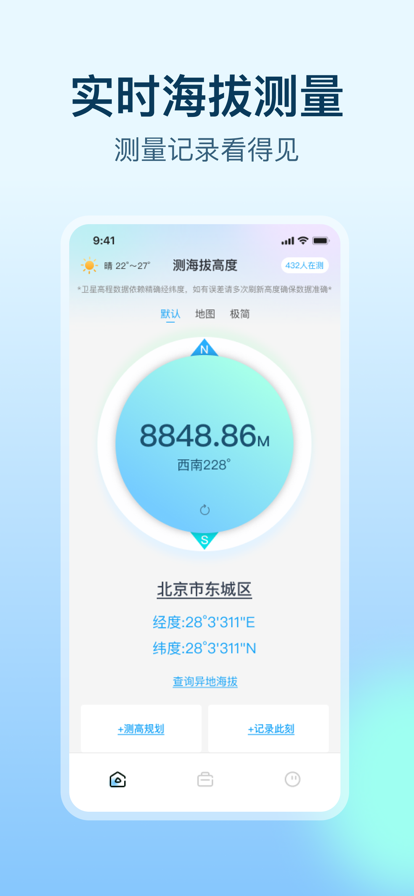
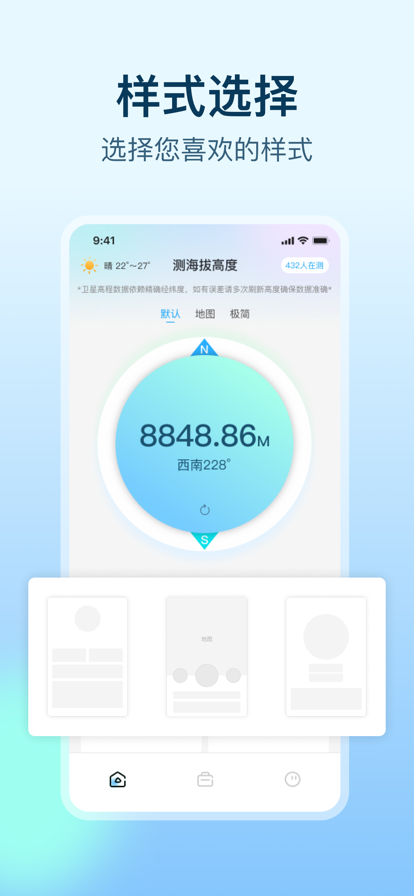
测海拔高度-实时高度表&无网络测量海拔&GPS海拔表为热爱登山,徒步,旅游等一系列户外活动的爱好者提供便捷。可快速获取当前海拔数据并生成动态热力图,每一个红点,都是一份信任,20万份信任汇聚成一个海拔热力图! 功能特色: 1.测海拔:测量当前位置海拔高度,可查看经纬度,风向,风速,气压等相关信息 2.海拔热力图:快速获取当前海拔数据并生成动态热力图,支持发布弹幕,记录和分享你的此时此刻,在这里留下你的来过的痕迹! 3.动物花草识别:随时随地一拍即知花草、动植物名称及百科信息 4.海拔拍摄:拍照记录此时此刻此景,支持在图片上添加时间地点、海拔高度、经纬度等信息水印,满足徒步、登山等场景需求。 5.异地测海拔:无需出门,在家就能测量国内各地海拔高度,在地图上点击任意位置就能查看经纬度,海拔高度等信息。 测海拔高度握在手,户外好帮手,路线小高手!无论是专业探险者还是旅行爱好者,都能一站式解决户外导航与行程规划需求。 ------------------------------------------- 【会员自动续费服务说明】 关于程序内提供的「按月订阅」功能: 您可以在程序内使用 iTunes 自动续订功能获取会员专属功能,我们提供「月度会员」套餐。 确认购买后,将会从您的 iTunes 帐户中收取费用。您可以在每个周期结束至少 24 小时前取消下个周期的订阅,每个周期结束 24 小时内将会自动续订,已订阅的周期将无法取消。 隐私保护政策:https://share.note.youdao.com/s/7VkMUTzh 用户使用协议:https://share.note.youdao.com/s/PRQgKQlN

作为GPS速度计,它支持测量步行,慢跑,骑自行车的速度。 它还支持测量汽车,轮船,火车或飞机的速度。 不管您是健身、驾驶还是乘坐各种交通工具, 用该应用程序,您都可以获得当前速度,高度和航向。 它支持双刻度:英制和公制同时显示,避免换算的麻烦。 它还支持记录行程和平均速度。 这也是一个高度计。 您可以在远足,爬山,徒步旅行,滑雪,飞行时检查海拔或海拔高度。即使在万米高空,您也可以获得飞机飞行的参数,从而对您的旅程了如指掌。您可以以英尺或米为单位查看它。 它附带一个用于飞行,航行或驾驶的专业罗盘。 拥有多个精美表盘可满足您的品味。

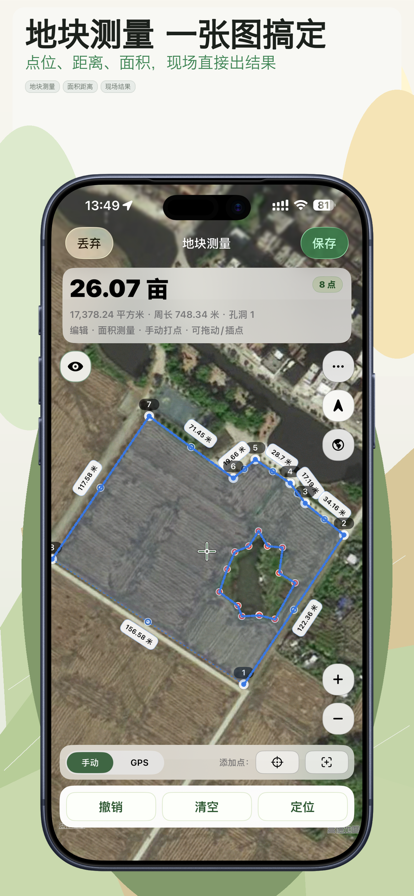
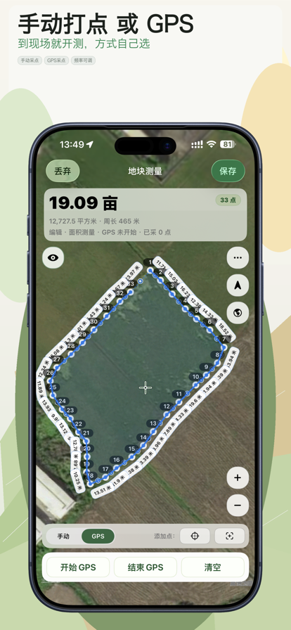
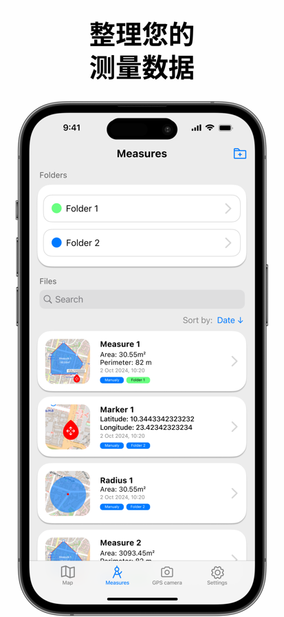
很多测量工具不是不能测,而是测完之后不好接着用。现场拿到了面积和边界,后面想再改、再查、再导出给别人,流程就散了。 地块测量做的就是把这件事理顺。 你可以在一张地图里完成三类记录: - 点位:记录地点和坐标 - 距离:记录路线、边线、围栏或通道长度 - 面积:记录农田、地块、场地或园区边界 现场采点支持两种方式: - 手动打点,适合精细落点 - GPS 采点,适合沿边界行走记录 测的过程中可以继续改: - 拖动点位 - 插入中点 - 实时更新长度和面积 - 对复杂地块做分割和挖孔 测完之后,记录也不会丢在流程里: - 历史记录支持搜索、筛选和分组 - 详情页可以查看地图、指标、坐标、附图和备注 - 支持从历史记录继续编辑,保存后覆盖原记录 如果你还要把结果交给别人继续用,也不用重新整理: - 导出支持 KML、图片、PDF、GeoJSON、Shapefile、CSV、DXF、TXT、GPX、Satloc(.job) - 导入支持 GeoJSON/JSON、KML、GPX、CSV、TXT、DXF、JOB - 导入前可先预览再确认 同时支持多语言、多单位和多种坐标格式,方便在不同地区和不同工作习惯下使用。 订阅说明 - Pro 提供月订阅和年订阅两种自动续费方案 - Pro 可解锁更多专业导出能力、iCloud 同步及图片无水印等高级功能 - 订阅费用将在确认购买时从 Apple ID 扣款 - 除非你在当前周期结束前至少 24 小时取消,否则订阅会自动续费 - 购买后可在 Apple ID 账户设置中管理或取消订阅 - 隐私政策:http://suwenclub.cn/apps/mapmeasure/privacy.html - 用户协议:http://suwenclub.cn/apps/mapmeasure/terms.html

一款户外达人旅游出行必备应用,帮助你获取当前位置海拔和指南针方向,还能参与全球用户海拔高度巅峰排行榜。


距离和土地 GPS 面积测量 这是一个免费工具,可使用 GPS 精确计算土地面积。借助精确的地图数据,您可以测量田地、绘制线条并确定地图上绘制的任何形状的面积。 GPS 面积测量的主要功能: - GPS 测量: 根据位置计算总面积。 - GPS 相机: 在您的相机照片上添加 GPS 标记,包括日期、时间、实时地图、纬度、经度、天气、磁场、指南针和海拔。 - 面积计算器: 添加点以定义地图上的封闭路径。保存测量区域以备将来使用,创建标记和组,并以 KML、KMZ 或 PDF 等格式导出结果。 — Subscription Options — We offer flexible subscription options with auto-renewal for either 1 month or 1 year or 1 week. Manage your subscriptions conveniently through your account settings, with the option to turn off auto-renewal if you choose. Privacy Policy - https://docs.google.com/document/d/1iraXRX8U3VbLaHv5SGyomjTTYdemuOyYu94o60UNpw0/ EULA - https://docs.google.com/document/d/1g4rJC5DSfnaAcXacTqerPBF4AIQ3Bj6F4d41ETAUqW0 Terms of Use - https://docs.google.com/document/d/1glrL374vhn1C78_2zUG7L1oSH4qT3SPWDfyw74uEaso/

指南针是一款集多功能于一体的实用工具应用,专为户外探险、旅行、日常出行设计。无论您是登山爱好者、野外露营者,还是需要精准方向的驾驶者,这款应用都能为您提供全方位的支持,确保您的行程便捷。 核心功能: 精准指南针 实时显示方向(东南西北),包含经纬度、海拔、气压,校准简单,指向精准,助您轻松辨别方位。 智能水平仪 高灵敏度水平测量工具,可用于调整家具、检查地面坡度,甚至辅助相机拍摄平衡画面。 实时天气监测 提供当前位置的温度、湿度、降水等实时天气数据,让您随时掌握天气变化,做好出行准备。 极端天气预警 显示大风、大雾、雷电、森林火灾等灾害预警信息,提前防范风险,保障安全。 水印相机 拍照时可添加时间、地点、海拔、天气等实用水印,记录旅行足迹或工作打卡,方便又专业。 应用特点: 界面简洁 - 直观易用,功能一目了然 离线使用 - 指南针、水平仪无需网络,随时随地可用 低功耗 - 优化电池使用,长时间户外使用无压力 用户协议:https://docs.qq.com/doc/p/61d8f9ce6b8a2a99f260e9fccb166d3218bf0f8a 隐私协议:https://docs.qq.com/doc/p/a797347c83fb739674545dcad91b847a7364b18f
平面仪 - 使用 GPS 在地图上测量距离、面积和土地面积 直接在地图上测量距离、面积和周长——快速、准确且易于使用。无论您是土地测量员、房地产经纪人、承包商、农民、园艺师,还是只是在规划后院,平面仪都可以帮助您在地图或地球上测量任何物体,只需在屏幕上轻点几下即可。 # 强大的 GPS 测绘和土地测量工具 平面仪可将您的 iPhone 或 iPad 变成专业级的测绘和测量工具。使用手指触摸屏幕或 GPS 追踪功能,在地图上放置点,即可立即计算面积、周长和距离。测量田地、房产、道路、小径、屋顶、围栏等。 # 功能 - 精确距离测量 - 公制和英制单位(米、公里、英尺、码、英里、公顷、英亩) - GPS 精度设置(如 GPS 可用) - 当前位置搜索 - 删除选定/最后一个/所有点 - 缩放以适应屏幕并将点置于中心 - 快速点搜索 - 通过触摸添加点 - 将当前位置添加为点 - 可选择将添加的点置于中心 - 可选择显示/隐藏线条 - 首选项:精度、追踪时间间隔、删除点确认、追踪声音选项 - 距离、面积和周长的单位分别设置。 # 高级功能(需订阅) - 面积计算 - 线与线之间的夹角 - 点与点之间的方位角 - 触摸信息面板,向前和向后导航 - 点的 GPS 坐标 - 管理之前保存的项目:打开、保存、共享 KML 文件 - Planimeter 创建的 KML 文件可以导入 GEarth 和 GMaps 并在桌面上查看 - 通过电子邮件发送数据:图片、坐标(短信)、KML 文件 - 将 KML 或 TXT 文件保存到本地存储 - 地图/卫星视图 - 缩放和编辑点 - 文本(地址)搜索 - 通过输入经纬度坐标查找位置 - 通过输入地理坐标(纬度和经度)添加点 - 目标模式,可精确放置图钉 - 在目标模式下显示当前坐标 - 绘图(手写笔)模式 - 笔记模式 # 完美适用于: - 土地测量和边界测绘 - 房地产地块大小和财产规划 - 农业(田地大小、围栏、规划) - 建筑、铺路、道路工程 - 太阳能电池板安装(估算屋顶面积) - 园林绿化、草坪护理和花园设计 - 户外运动、徒步旅行、高尔夫球场规划、步道测量 - 林业、损失评估等 # 了解更多 快速入门指南在此页: https://www.vistechprojects.com/vistech-projects-downloads 视频演示:https://youtu.be/unjYbPCIYM0 # 注意 持续在后台运行 GPS 会显著缩短电池续航时间。 # 深受专业人士和 DIY 用户的喜爱 Planimeter 深受全球测量、农业、房地产、太阳能和建筑专业人士以及房主和户外运动爱好者的信赖。立即加入成千上万的用户,简化他们的土地测量任务。 # 如有任何问题或反馈?请发送电子邮件至 support@vistechprojects.com 联系我们


指南针,一款专业的指南针定位工具,利用网络和GPS、手机传感器等数据来确定您所在地的天气经纬度海拔等信息,同时支持实时显示GPS信息、GPS测速以及海拔高度,天气、气压、风向等实用信息,方便您更便捷的了解所处地理位置情况。 功能特性: - 根据定位信息,显示经纬度 海拔 天气等数据 - 支持风向、海拔记录等功能 - 支持GPS测速功能 - 支持相机拍照显示经纬度 获取订阅内容: 1. 获取全部精确地理数据 2. GPS测量速度次数不限 3. 经纬相机记录次数不限 4. 流畅无广告体验 * 我们的标准订阅选项为: 提供专业版订阅,包含连续包年的订阅,订阅会自动更新,期间可告别广告打扰;不限制使用所有功能,解锁所有专业版内容,优先享受功能更新。 * 在您确认购买时和每个续费周期开始时,我们会从您的 iTunes 账户中收取订阅费用。 包含免费试用期的订阅将自动续订为付费订阅。 在免费试用期结束前至少 24 小时,您可以在 iTunes 设置中取消您的订阅或免费试用。 取消订阅将会在当前订阅周期最后一天后生效,一旦取消订阅生效,您的订阅服务权限将失效。 隐私政策:https://docs.qq.com/doc/DUENpcFdPWVRiQnhQ 用户协议:https://docs.qq.com/doc/DUGZ5TGJjRnlzcmll